


1-Voting District, Wakulla County, Florida
About
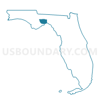
Outline

Summary
| Unique Area Identifier | 560150 |
| Name | 1-Voting District |
| County | Wakulla County |
| State | Florida |
| Area (square miles) | 81.86 |
| Land Area (square miles) | 81.49 |
| Water Area (square miles) | 0.36 |
| % of Land Area | 99.56 |
| % of Water Area | 0.44 |
| Latitude of the Internal Point | 30.23130850 |
| Longtitude of the Internal Point | -84.18110150 |
Maps


Graphs
Select a template below for downloading or customizing gragh for 1-Voting District, Wakulla County, Florida


Neighbors
Neighoring Voting District (by Name) Neighboring Voting District on the Map
- 11-Voting District, Wakulla County, FL
- 12-Voting District, Wakulla County, FL
- 12-Voting District, Jefferson County, FL
- 1257-Voting District (Woodville Community Center), Leon County, FL
- 2251-Voting District (Woodville Community Center), Leon County, FL
- 2252-Voting District (Woodville Community Center), Leon County, FL
- 5-Voting District, Wakulla County, FL
- 8-Voting District, Wakulla County, FL
Top 10 Neighboring County Subdivision (by Population) Neighboring County Subdivision on the Map
- East Wakulla CCD, Wakulla County, FL (25,500)
- Southeast Leon CCD, Leon County, FL (15,549)
- Wacissa CCD, Jefferson County, FL (4,380)
Top 10 Neighboring Place (by Population) Neighboring Place on the Map
Top 10 Neighboring Unified School District (by Population) Neighboring Unified School District on the Map
- Leon County School District, FL (275,487)
- Wakulla County School District, FL (30,776)
- Jefferson County School District, FL (14,761)
Top 10 Neighboring State Legislative District Lower Chamber (by Population) Neighboring State Legislative District Lower Chamber on the Map
- State House District 7, FL (169,309)
- State House District 8, FL (152,934)
- State House District 10, FL (151,214)
Top 10 Neighboring State Legislative District Upper Chamber (by Population) Neighboring State Legislative District Upper Chamber on the Map
Top 10 Neighboring 111th Congressional District (by Population) Neighboring 111th Congressional District on the Map
Top 10 Neighboring Census Tract (by Population) Neighboring Census Tract on the Map
- Census Tract 102.03, Wakulla County, FL (8,867)
- Census Tract 102.02, Wakulla County, FL (8,332)
- Census Tract 26.03, Leon County, FL (4,991)
- Census Tract 2502, Jefferson County, FL (4,380)
- Census Tract 26.04, Leon County, FL (3,108)